

Botanical Ink Wash Drawings, Jacques AragoBack to Gallery
Mariana Islands
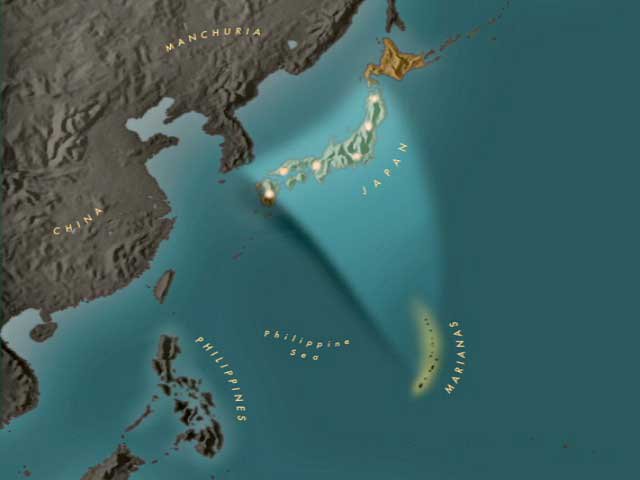
The Mariana Islands (also the Marianas; up to the early 20th century sometimes called Ladrones Islands, from Spanish Islas de los Ladrones meaning "Islands of Thieves") are an arc-shaped archipelago made up by the summits of 15 volcanic mountains in the north-western Pacific Ocean between the 12th and 21st parallels north and along the 145th meridian east. They are south of Japan and north of New Guinea, and immediately to the east of the Philippine Sea. The south end of the Marianas chain is the island of Guam. The islands were named after Spanish Queen Mariana of Austria in the 17th century, when Spain started the colonization of the archipielago.
The islands are part of a geologic structure known as the Izu-Bonin-Mariana Arc system, and range in age from 5 million years old in the north to 30 million years old in the south (Guam). The island chain arises as a result of the western edge of the Pacific Plate moving westward and plunging downward below the Mariana plate, a region which is the most volcanically active convergent plate boundary on Earth. This subduction region, just east of the island chain, forms the noted Mariana Trench, the deepest part of the Earth's oceans and lowest part of Earth's crust. In this region, according to geologic theory, water trapped in the extensive faulting of the Pacific Plate as serpentinite, is heated by the higher temperatures of depth during its subduction, and the pressure from the expanding steam results in the hydrothermal activity in the area, and the volcanic activity which formed the Mariana Islands.
The Marianas islands are the northern part of the Micronesia island group, although their government is under a different jurisdiction from much of the rest of geographical Micronesia. Today, the Marianas Islands are composed of two U.S. jurisdictions: the territory of Guam and the Commonwealth of the Northern Mariana.